Weather data & microclimate :
Weather
Weather Data Microclimate Insights For Outdoor Enthusiasts
App Screenshots


About Weather Data & Microclimate Features
Weather Data & Microclimate is a professional-grade meteorological application designed for users who require precise, hyper-local weather information. It transcends standard forecasts by leveraging advanced data sources and modeling to provide detailed insights into microclimates—the distinct climate conditions of a small, specific area that may differ from the surrounding region. The app serves as a powerful tool for planning, analysis, and decision-making, catering to both professionals and enthusiasts who depend on accurate atmospheric data.
Chapter 1: Function
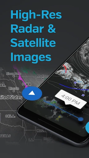
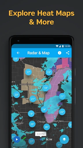
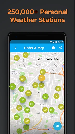
The core functionality of Weather Data & Microclimate centers on delivering highly granular and reliable weather data. It provides real-time and forecasted parameters including temperature, humidity, wind speed and direction, precipitation probability and intensity, barometric pressure, and UV index. A defining feature is its microclimate mapping, which uses topographical data, urban heat island effects, and local sensor networks to visualize weather variations within a city or a natural landscape. Users can access detailed radar and satellite imagery, historical weather data archives, and customizable alerts for specific conditions like frost, high winds, or rainfall thresholds. The interface typically allows for tracking multiple saved locations and presents data through clear charts, graphs, and map overlays.
Chapter 2: Value
The primary value proposition of Weather Data & Microclimate lies in its precision and depth, offering significant advantages over conventional weather apps. Its key advantage is the ability to reveal microclimate variations, empowering users with knowledge that a general forecast for a large area cannot provide. For instance, it can show temperature differences between a valley and a hillside, or rainfall disparities across different city districts. This precision is invaluable for risk mitigation and optimized planning. The app aggregates data from authoritative sources, including government meteorological agencies, personal weather stations, and proprietary models, ensuring reliability. Furthermore, the inclusion of historical data analytics allows users to identify patterns and trends, supporting long-term decision-making. The customizable alert system acts as a proactive safeguard, notifying users of exact conditions that matter to their specific activities or assets. By transforming raw meteorological data into actionable intelligence, the app provides a tangible return on investment through saved time, reduced losses, and enhanced safety and productivity for its users.
Chapter 3: Scenarios
This app is ideally suited for user groups whose activities are sensitive to subtle environmental changes. Primary users include agricultural professionals, such as farmers and vineyard managers, who rely on precise frost, rain, and heat data to protect crops and schedule harvests. It is equally vital for outdoor event planners, construction site managers, and logistics coordinators who need to anticipate local conditions to ensure safety and adhere to timelines. Enthusiasts like gardeners, hikers, sailors, and pilots benefit from its detailed wind, storm, and visibility forecasts for safer and more enjoyable experiences. Additionally, researchers, educators, and environmental consultants utilize its historical data and microclimate maps for studies and projects. In everyday use, a gardener might check the app to determine the exact frost risk in their specific backyard microclimate before covering plants. A drone photographer could use it to find a time window with perfect light and calm winds at a precise hilltop location, demonstrating the app's role in enabling informed, location-specific decisions.
Key Pros
- hyper-local microclimate forecasts for gardens and farms
- integrates personal weather station data with official sources
- provides actionable alerts for frost
- heat
- and watering
- offers historical microclimate trends for specific locations
- minimalist interface focuses solely on agricultural metrics
Things to Note
- requires user-placed sensors for best accuracy
- interface lacks general weather entertainment features
- data depth can be overwhelming for casual users
- premium features are essential for commercial planning
- limited usefulness in regions without dense station networks
Frequently Asked Questions
Q: What is Weather Data & Microclimate app?
A: Weather Data & Microclimate is a specialized weather application focused on providing hyper-local weather data and microclimate information. It goes beyond standard forecasts by offering detailed atmospheric conditions for very specific locations, which is valuable for activities like gardening, hiking, or farming. The app uses various data sources to model differences in temperature, humidity, and wind within small geographic areas.
Q: Is this app free to use or does it have in-app purchases?
A: The app operates on a freemium model. You can download and access basic weather data and microclimate information for free. However, advanced features such as detailed historical data, high-resolution forecast models, severe weather alerts, or ad-free experience typically require a subscription or one-time in-app purchase. The specific pricing tiers are listed within the app's store page.
Q: What devices and systems is this app compatible with?
A: Weather Data & Microclimate is primarily available for modern Android and iOS smartphones and tablets. It requires a stable internet connection (cellular or Wi-Fi) to fetch the latest data. The app may utilize device sensors like GPS for precise location. For optimal functionality, it is recommended to use devices running recent versions of their respective operating systems.
Q: How accurate is the microclimate data provided?
A: The app synthesizes data from public weather stations, satellite information, and proprietary modeling algorithms to estimate microclimate conditions. While it aims for high precision, its accuracy can vary with terrain complexity, data source density, and rapid weather changes. It is a valuable tool for identifying local trends but should not be solely relied upon for critical safety decisions in volatile conditions.
Q: Can I access historical weather data with this app?
A: Access to historical weather data is typically a premium feature. The free version may offer very limited historical information. A subscription usually unlocks detailed historical data archives, allowing you to view past temperature, precipitation, and other metrics for your specific location, which is useful for tracking patterns and planning. Check the in-app purchase options for specific capabilities.