Weather Radar: Forecast & Maps
Weather
Live Weather Radar Maps Alerts For Outdoor Plans
App Screenshots
About Weather Radar: Forecast & Maps Features
Weather Radar: Forecast & Maps is a comprehensive mobile application designed to deliver hyper-local, real-time weather information and detailed forecasts. It distinguishes itself by providing professional-grade radar maps, severe weather alerts, and customizable tracking features, all within a user-friendly interface. The app serves as a powerful tool for anyone needing precise and timely atmospheric data, transforming complex meteorological information into accessible and actionable insights for daily planning and safety.
Chapter 1: Function
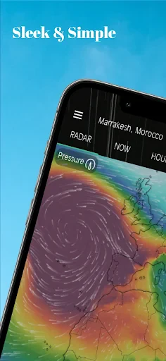
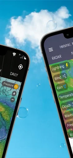
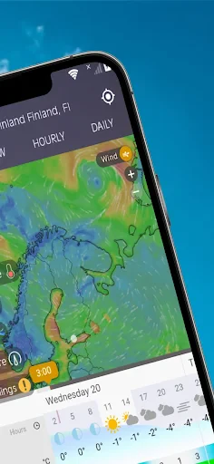
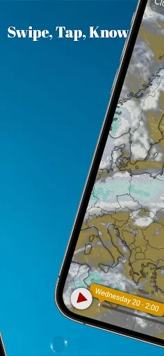
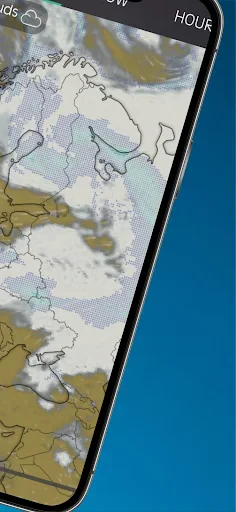
The core functionality of Weather Radar: Forecast & Maps centers on delivering precise, location-based weather data. Its primary feature is an interactive, animated radar map that displays real-time precipitation, storm cells, and other weather patterns using data from official sources. Users can zoom, pan, and overlay different map layers, such as satellite, temperature, and wind speed. The app provides detailed hourly and extended forecasts, including temperature, humidity, wind direction, and precipitation probability. A critical function is its push notification system for severe weather alerts, including thunderstorms, hurricanes, and tornado warnings. Additionally, users can save multiple locations, track specific storms, and view future radar projections to anticipate weather movements.
Chapter 2: Value
The value proposition of Weather Radar: Forecast & Maps lies in its depth, accuracy, and proactive utility, offering significant advantages over basic weather apps. Its foremost advantage is the professional-level radar interface, which provides granular, real-time visualization of weather systems. This empowers users to see not just what the weather is, but where it is moving, enabling personal forecasting. The app aggregates data from authoritative meteorological services, enhancing reliability. For personal safety, its customizable alert system is invaluable, providing early warnings for severe conditions directly to a user's device, which can be crucial for taking timely protective action. Beyond safety, the app delivers substantial practical value for daily planning. Detailed, hyper-local forecasts help users make informed decisions about activities, commutes, and attire, minimizing weather-related disruptions. The ability to monitor multiple locations is beneficial for travelers or those with family in different areas. The intuitive design makes sophisticated data understandable for the average user, while the ad-free experience in its premium version ensures uninterrupted access. Ultimately, it demystifies complex weather data, putting the power of a personal meteorologist in the user's pocket, fostering preparedness and confidence in the face of unpredictable conditions.
Chapter 3: Scenarios
Weather Radar: Forecast & Maps caters to a broad spectrum of users whose daily decisions are influenced by meteorological conditions. Primary user groups include outdoor enthusiasts such as hikers, campers, boaters, and golfers who require precise, hourly forecasts and radar views to plan activities safely and avoid storms. It is equally essential for professionals whose work is weather-dependent, including construction managers, event planners, farmers, and logistics personnel. Commuters and frequent travelers form another key demographic, using the app to check conditions along routes and at destinations to anticipate delays and pack appropriately. Parents and caregivers use it to plan children's outdoor activities and receive alerts for school-day weather hazards. Furthermore, it is a vital tool for residents in regions prone to volatile weather, such as tornado alleys or hurricane coasts, providing a critical layer of safety through its alert system. Everyday use cases range from checking morning radar to decide on carrying an umbrella, to monitoring a developing thunderstorm while at a park, to tracking a hurricane's path days in advance for evacuation planning.
Key Pros
- offers minute-by-minute precipitation tracking on animated maps
- integrates live webcam feeds from user-submitted local weather stations
- provides customizable severe weather push notifications for specific locations
- displays high-resolution future radar forecasts up to 24 hours ahead
- uses a minimalist map interface focused solely on radar data layers
Things to Note
- requires subscription for advanced features like hurricane tracking models
- live webcam coverage is sparse in rural or less-populated regions
- high-resolution radar maps consume significant mobile data quickly
- lifestyle forecasts (e.g.
- pollen
- fishing) are not included in the app
- animated maps may stutter on older devices with limited processing power
Frequently Asked Questions
Q: What is Weather Radar: Forecast & Maps?
A: Weather Radar: Forecast & Maps is a mobile weather application focused on providing real-time animated radar maps, detailed forecasts, and severe weather alerts. Its core positioning is to offer hyper-local, visual weather tracking, primarily through interactive radar and storm tracking features. It is designed for users who need detailed meteorological data beyond basic temperature and conditions.
Q: Is the app free to use, or does it have in-app purchases?
A: The app sources its radar data from official meteorological services, providing real-time and forecast radar animations. The detail and update frequency depend on your region and data providers. It typically offers multiple layers (like precipitation, clouds, storms) and allows for zooming and panning. Accuracy is consistent with standard public radar data but can vary with local conditions and data latency.
Q: What devices and operating systems does this app support?
A: The app operates on a freemium model. You can download and use basic features like current conditions and standard forecasts for free. However, access to advanced features such as high-resolution radar, future radar loops, severe weather alerts, and ad-free experience typically requires a subscription or one-time in-app purchase. Specific pricing is set within the app store.
Q: How accurate and detailed are its radar maps?
A: Weather Radar: Forecast & Maps is primarily available for iOS and Android devices, including smartphones and tablets. It generally supports recent versions of these operating systems. The app does not require additional external hardware. For optimal performance of radar maps, a stable internet connection (cellular data or Wi-Fi) and location services permissions are necessary.
Q: How do I set up severe weather alerts for my location?
A: To receive alerts, ensure location permissions are enabled for the app. You can usually set your location manually or allow automatic GPS detection. Notification permissions must also be granted in your device settings. The app will then push alerts based on your saved locations. For issues with alerts not appearing, check your device's notification settings for the app and ensure a stable data connection.