RadarNow! ®
Weather
Storm Tracking Alerts For Severe Weather Safety
App Screenshots


About RadarNow! ® Feature - Real-Time Weather Tracking at Your Fingertips
RadarNow! ® is a professional-grade weather radar application designed to deliver precise, real-time meteorological data directly to mobile devices. It stands out by providing high-resolution animated radar imagery, severe weather alerts, and detailed forecasting tools. The app caters to users who require more than basic weather updates, serving as a reliable companion for planning daily activities, travel, and preparing for significant weather events. By aggregating data from authoritative sources and presenting it through an intuitive interface, RadarNow! ® transforms complex weather information into actionable insights for both casual users and weather enthusiasts.
Chapter 1: Function
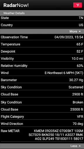
RadarNow! ® specializes in delivering dynamic, real-time weather radar and forecasting. Its core functionality centers on interactive, animated radar maps that display precipitation types, storm cell movement, and intensity with high resolution. Users can zoom, pan, and loop radar imagery to observe weather patterns over specific timeframes. The app provides detailed local forecasts, including temperature, humidity, wind speed and direction, and barometric pressure trends. A critical function is its push notification system for National Weather Service (NWS) alerts, warning users of severe conditions like thunderstorms, tornadoes, floods, and winter storms. Additional features include hurricane tracking with forecast cones, lightning strike data overlay, and the ability to save and monitor multiple locations simultaneously.
Chapter 2: Value
The primary value of RadarNow! ® lies in its precision, timeliness, and depth of data, offering users a significant advantage in weather awareness and safety. Unlike many standard weather apps, it provides professional-level radar imagery that is crucial for understanding storm development and trajectory. This granular detail empowers users to make informed decisions, whether deciding to postpone an outdoor event or seeking shelter ahead of severe weather. The app's reliance on official NWS alerts ensures reliability, reducing the risk of missing critical warnings. Its user interface, while feature-rich, is designed for clarity, allowing quick interpretation of complex data. For outdoor professionals, event planners, aviators, mariners, and severe weather hobbyists, the app acts as a portable weather station. The absence of advertisements in its premium experience further enhances usability during urgent situations. By consolidating multiple data streams—radar, alerts, forecasts, and lightning—into a single, responsive application, RadarNow! ® delivers exceptional value as a comprehensive, trustworthy tool for proactive weather monitoring and risk management.
Chapter 3: Scenarios
RadarNow! ® is ideally suited for individuals whose schedules, safety, or hobbies are heavily influenced by weather conditions. Primary user groups include outdoor enthusiasts such as boaters, fishermen, pilots, hikers, and golfers who need to assess real-time conditions and short-term forecasts before and during their activities. It is equally valuable for professionals in agriculture, construction, and event planning, where weather can impact operational safety and logistics. Parents and homeowners use the app to monitor approaching storms to ensure family safety and protect property. Travelers rely on it to check weather along routes and at destinations, aiding in smoother trip planning. Furthermore, storm chasers and weather aficionados utilize its detailed radar and tracking features for observation and documentation. In everyday use, a commuter might check the app to see if rain will hit during their drive home, a gardener might use it to plan watering around impending showers, and a family might monitor its alerts during a tornado watch to know precisely when to take cover.
Key Pros
- displays real-time aircraft positions overlaid on a live camera view
- identifies aircraft by flight number
- model
- and altitude instantly
- works offline using cached map and aircraft database
- augmented reality mode aligns flight paths with the actual sky
- minimal interface focuses solely on live aircraft tracking
Things to Note
- requires clear sky visibility for accurate AR calibration
- detailed aircraft data depends on occasional database updates
- persistent GPS use drains battery rapidly during extended sessions
- core tracking feature offers limited airport or schedule info
- AR mode can be unstable on older device hardware
Frequently Asked Questions
Q: What is RadarNow! and what does it do?
A: RadarNow! is a weather radar application focused on real-time precipitation tracking and storm monitoring. Its core function is displaying high-resolution, live radar maps with animated loops to show storm movement. The app provides severe weather alerts, customizable map layers, and detailed storm data. It is designed for personal weather monitoring and situational awareness.
Q: Is RadarNow! free to use or does it have in-app purchases?
A: RadarNow! operates on a freemium model. The app can be downloaded for free, which includes access to basic real-time radar and standard alerts. It offers optional in-app purchases for premium features, such as higher-resolution radar data, advanced storm analytics, future radar forecasts, and an ad-free experience. Subscription details are available within the app.
Q: On which devices and operating systems is RadarNow! available?
A: RadarNow! is primarily available for iOS and Android mobile devices. It is optimized for smartphones and tablets. The app requires a stable internet connection (cellular data or Wi-Fi) for real-time data fetching. It typically supports recent versions of the respective operating systems. For specific version requirements, please check the official listing on the Apple App Store or Google Play Store.
Q: How accurate and timely is the radar data in the app?
A: The app sources its radar data from official meteorological services, such as the National Weather Service in the US. The data is updated frequently, typically every 2-10 minutes, depending on the region and radar site. While it provides real-time information, all radar data has inherent limitations in range and precision, and should be used as a guidance tool alongside official weather warnings.
Q: Does the app provide severe weather alerts and notifications?
A: Yes, RadarNow! provides customizable severe weather alerts for defined locations. Users can set alert types for events like thunderstorms, tornadoes, or heavy precipitation. Notifications are pushed to the device based on National Weather Service issuances or radar-indicated criteria. Alert reliability depends on data service availability and the user's device notification settings.