Weather Live - Radar & Alerts
Weather
Accurate Weather Forecasts And Alerts For Everyone
App Screenshots


About Weather Live - Radar & Alerts Feature
Weather Live - Radar & Alerts is a professional-grade mobile application designed to deliver hyper-local, real-time weather information and severe weather warnings. It stands out by combining detailed animated radar maps, precise forecasts, and proactive alert systems into a single, user-friendly interface. The app serves as a comprehensive tool for individuals who need reliable and timely weather data to plan their days, safeguard their activities, and make informed decisions based on atmospheric conditions. By leveraging data from official meteorological sources and proprietary tracking technology, it transforms complex weather data into accessible visual formats and actionable insights for everyday use.
Chapter 1: Function
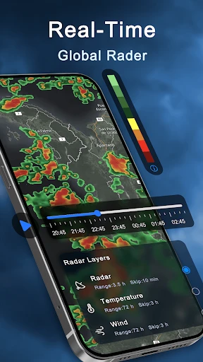
The core functionality of Weather Live revolves around its dynamic radar and comprehensive forecasting. The app provides a high-definition, animated weather radar map that allows users to track precipitation, storms, snow, and other weather phenomena in real-time, with the ability to zoom in to a street-level view. It offers detailed hourly and extended forecasts, including metrics for temperature, humidity, wind speed and direction, precipitation probability, and atmospheric pressure. A critical function is its alert system, which pushes notifications for severe weather warnings issued by official agencies, such as thunderstorms, hurricanes, tornadoes, and floods, directly to the user's device. Additional features include satellite cloud overlays, weather widgets for the home screen, and customizable tracking for multiple global locations.
Chapter 2: Value
The primary value proposition of Weather Live - Radar & Alerts lies in its precision, reliability, and proactive safety features. Unlike basic weather apps, it provides professional-level radar tools that empower users to visualize weather patterns moving in their exact area, offering a significant advantage for planning. The app aggregates data from multiple authoritative sources, including national weather services and next-generation radar networks, ensuring forecasts and alerts are accurate and trustworthy. Its key advantage is the customizable alert system, which can provide life-saving early warnings for severe weather, giving users crucial time to take shelter or alter plans. The interface is designed for clarity, presenting complex meteorological data through intuitive maps and graphs that are easy for non-experts to understand. Furthermore, the absence of distracting ads in its premium version ensures an uninterrupted experience during critical weather events. This combination of detailed visualization, reliable data sourcing, and user-centric design makes it an invaluable tool for anyone whose daily decisions are influenced by weather conditions, transforming passive observation into active preparedness.
Chapter 3: Scenarios
Weather Live is ideally suited for a wide range of users whose routines are weather-dependent. Primary user groups include outdoor enthusiasts such as hikers, cyclists, campers, and fishermen, who rely on precise, hyper-local forecasts and radar to plan safe excursions and avoid sudden storms. It is equally valuable for professionals in agriculture, construction, event planning, and logistics, where weather impacts operational efficiency and safety. Parents and school administrators use it to monitor conditions for children's outdoor activities and commute safety. Daily commuters benefit from its real-time radar to navigate around rain showers or severe weather during their travels. The app is also essential for residents in regions prone to volatile weather, such as tornado alleys, hurricane coasts, or areas with frequent thunderstorms, as the timely alerts provide a critical layer of personal security. In everyday use, a user might check the app in the morning to decide on attire, consult the radar map before an evening walk to see approaching rain, and rely on its alerts for warnings about overnight severe weather, making it a central hub for all weather-related decision-making.
Key Pros
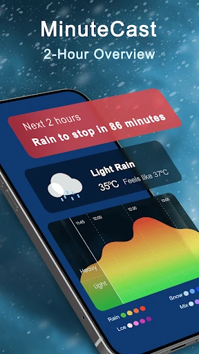
- hyper-local rain start/stop forecasts via minutecast
- seamless looping future radar for storm path visualization
- offline access to saved radar maps and storm tracks
- push alerts for lightning strikes within 10 miles
- professional-grade dual-polarization radar data layers
Things to Note
- requires subscription for advanced alert customization
- high data usage when streaming hd radar loops
- minutecast accuracy decreases significantly in mountainous regions
- storm chaser mode drains battery rapidly with gps active
- no crowd-sourced road condition or hail size reports
Frequently Asked Questions
Q: What is Weather Live - Radar & Alerts?
A: Weather Live is a mobile weather application focused on providing hyper-local forecasts, real-time animated radar maps, and severe weather alerts. Its core positioning is as a detailed, visual tool for tracking precipitation, storms, and weather patterns. Key features include high-resolution radar animations, customizable alert notifications for your exact location, and various map layers (like temperature, wind, and satellite).
Q: Is the app free to use, or does it have in-app purchases?
A: Weather Live - Radar & Alerts is primarily available for iOS and Android devices (smartphones and tablets). It is designed for recent versions of these operating systems. The app does not require additional external hardware. It uses your device's location services (with your permission) to provide personalized forecasts and alerts. For specific version requirements, please check your device's app store listing.
Q: Can I get severe weather alerts for my specific location?
A: The app operates on a freemium model. You can download and use basic features like current conditions and standard radar for free. However, advanced features such as high-resolution radar, future radar forecasts, detailed storm tracking, and ad-free experience typically require a subscription or one-time purchase through in-app purchases. Specific pricing tiers are listed within the app's store page.
Q: How accurate and detailed is the live radar feature?
A: The app sources its radar data from official meteorological services, providing real-time, animated precipitation maps. The detail level depends on your region and data availability. A key technical feature is the ability to loop radar animations to track storm movement. For higher resolution and future radar (forecast radar), a premium subscription is usually required. Accuracy is dependent on the underlying data providers.
Q: What devices and operating systems does the app support?
A: Yes, a core function is providing customizable push notifications for severe weather alerts (like thunderstorms, tornadoes, floods) issued for your saved or current location. You must enable location permissions and notification settings for the app. The alerts are based on official warnings from governmental weather agencies. You can typically manage alert types and sensitivity within the app's settings.