NOAA Weather & Tides
Weather
NOAA Weather Tides Marine Forecasts Boaters Fishermen
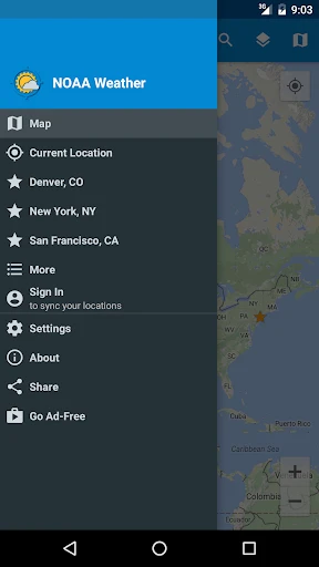
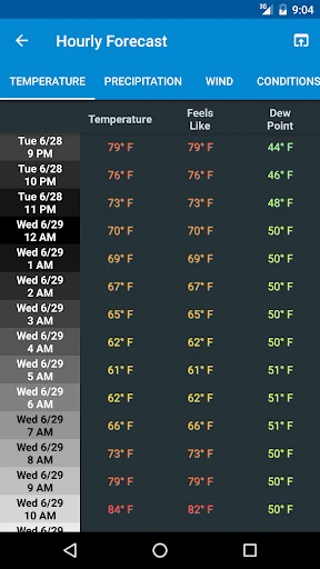
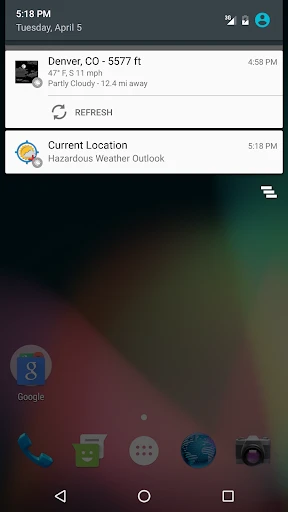
App Screenshots


About NOAA Weather & Tides Feature – Your Official Source for Hyperlocal Forecasts
NOAA Weather & Tides is an official mobile application developed in partnership with the National Oceanic and Atmospheric Administration, delivering authoritative and highly localized weather, ocean, and tidal data. It serves as a direct portal to NOAA's vast network of observation systems and forecast models, providing users with reliable, detailed environmental information. The app is designed for individuals whose daily plans and safety depend on precise atmospheric and marine conditions, from coastal residents and mariners to outdoor enthusiasts and weather aficionados. By consolidating critical data such as real-time radar, severe weather alerts, tide charts, and buoy reports into a single, user-friendly interface, it stands as a trusted tool for informed decision-making based on the most current official U.S. government forecasts.
Chapter 1: Function
The core functionality of NOAA Weather & Tides centers on delivering precise, location-based environmental intelligence. It provides comprehensive seven-day weather forecasts, including temperature, precipitation probability, wind speed and direction, and humidity. A key feature is its detailed tidal information, offering daily high and low tide times and heights for thousands of coastal and estuarine locations across the United States. The app integrates real-time NOAA weather radar and satellite imagery, allowing users to track storm movements visually. It actively pushes National Weather Service (NWS) alerts for severe conditions like hurricanes, thunderstorms, and floods directly to the user's device. Furthermore, it offers access to data from coastal buoys and weather stations, reporting wave height, water temperature, and swell period, which is crucial for marine activities. All data is sourced directly from NOAA's operational systems, ensuring scientific accuracy and timeliness.
Chapter 2: Value
The primary value proposition of NOAA Weather & Tides lies in its official authority and unparalleled reliability for hyperlocal data. Unlike many crowd-sourced or privately modeled weather apps, this application draws directly from the source: the U.S. government's primary scientific agency for weather and ocean prediction. This eliminates guesswork and provides a trusted single source of truth, which is critical for safety-sensitive activities like boating, fishing, or storm preparation. Its integration of terrestrial weather with marine and tidal data in one platform offers exceptional convenience for coastal users, who would otherwise need to consult multiple disjointed sources. The app's value is amplified by its proactive alert system for life-threatening weather, providing potentially life-saving notifications with the official weight of the NWS. The interface, while data-rich, is designed for clarity, presenting complex meteorological and oceanographic information in an accessible format. This combination of authoritative data, comprehensive scope, and focused design delivers significant practical value, empowering users to plan with confidence, mitigate risks, and deepen their understanding of local environmental patterns based on the gold standard of U.S. forecasting.
Chapter 3: Scenarios
The app is indispensable for specific user groups whose routines are intimately tied to environmental conditions. Mariners and boating enthusiasts rely on it for voyage planning, using tide charts to navigate inlets and avoid running aground, while buoy data informs them of sea state safety. Fishermen use it to pinpoint optimal fishing times based on tidal flows and weather windows. Coastal residents and property owners depend on its severe weather alerts and radar to prepare for and monitor storms, hurricanes, and coastal flooding. Outdoor professionals, including tour operators, surf instructors, and construction supervisors, use its precise forecasts to schedule activities and ensure client and crew safety. Avid outdoor recreational users, such as hikers, kayakers, and beachgoers, consult it to choose the best days and times for their excursions, avoiding inclement weather or dangerous water conditions. Finally, weather hobbyists and students value the app for its direct access to raw observational data and official forecasts, using it as an educational tool to study meteorology and oceanography in real-time.
Key Pros
- integrates marine tide charts with hyperlocal weather forecasts
- official NOAA data ensures high meteorological authority
- offline access to radar and forecasts aids remote coastal use
- detailed buoy data for real-time sea conditions
- minimalist interface prioritizes boating and fishing metrics
Things to Note
- interface lacks customization for non-mariner users
- high precision data limited to U.S. coastal regions
- graphics and animations less polished than mainstream apps
- requires manual location input for precise tide stations
- no integrated social or crowd-sourced weather reports
Frequently Asked Questions
Q: What is NOAA Weather & Tides and what does it do?
A: NOAA Weather & Tides is a free weather and marine forecast application. It provides official data from the U.S. National Oceanic and Atmospheric Administration (NOAA), including detailed weather forecasts, severe weather alerts, radar maps, and tide tables. Its core positioning is to be a reliable tool for outdoor enthusiasts, boaters, fishermen, and anyone needing accurate marine and terrestrial weather information directly from a trusted government source.
Q: Is NOAA Weather & Tides completely free to use?
A: Yes, the NOAA Weather & Tides app is free to download and use. It does not require any subscription or in-app purchases to access its core weather forecasts, radar, alerts, and tide data. The app is supported by non-intrusive banner advertisements. There is no need for additional hardware, though it requires standard permissions like location services for personalized forecasts and network access to fetch the latest NOAA data.
Q: What devices and regions does this app support?
A: The app is available for iOS and Android devices. While it primarily sources data for United States territories, including coastal and inland areas, its global weather models can provide basic forecasts for international locations. It is particularly optimized for users in the U.S. who need hyper-local marine conditions. The interface and data are in English. It is suitable for a wide range of users, from professionals to the general public.
Q: How accurate and detailed are the tide predictions?
A: The tide predictions are sourced directly from NOAA's extensive network of tide stations, making them highly accurate and reliable for U.S. coasts. The app provides daily high and low tide times and heights for thousands of stations. Users can view tide charts and set favorite locations. It is a core technical feature tailored for the boating and fishing category, offering essential data for planning water-based activities safely and effectively.
Q: Why is my location not updating or showing incorrect data?
A: Incorrect location data usually stems from device settings. Ensure location/GPS permissions are enabled for the app in your phone's settings. For the most precise marine forecasts and tide stations, manually search for and select your desired location. The app relies on a stable internet connection to fetch the latest NOAA data; offline functionality is limited. If problems persist, try restarting the app or your device to refresh the data connection.