UAV Forecast for Drone Pilots
Weather
UAV Forecast Drone Flight Weather Safety App
App Screenshots


About UAV Forecast for Drone Pilots Feature
UAV Forecast is a specialized mobile application designed for drone pilots, providing critical weather and environmental data essential for safe and compliant flight operations. It consolidates key parameters such as wind speed, visibility, cloud cover, and GPS satellite availability into a single, user-friendly interface. The app's primary goal is to help pilots make informed go/no-go decisions by assessing whether current conditions meet both regulatory requirements and personal safety thresholds. By serving as a pre-flight planning tool, UAV Forecast has become an indispensable utility for recreational and professional drone operators worldwide, aiming to mitigate risks associated with adverse weather and poor satellite connectivity.
Chapter 1: Function
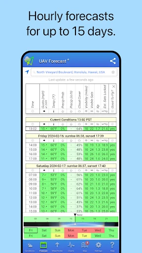
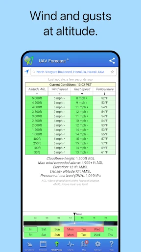
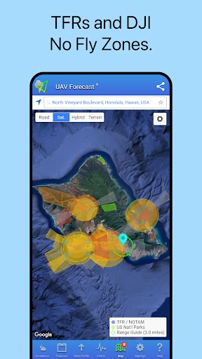
UAV Forecast delivers a comprehensive suite of pre-flight planning functions centered on weather and flight legality. Its core functionality involves displaying real-time and forecasted weather data specific to the pilot's location, including wind speed and gusts at various altitudes, temperature, humidity, precipitation probability, and visibility. Crucially, it features a detailed KP index display, which indicates geomagnetic storm activity that can disrupt GPS signals. The app provides a visual satellite map showing GPS and GLONASS satellite count and positions, along with a prediction of the best times for optimal satellite coverage. Furthermore, it integrates airspace information, highlighting temporary flight restrictions (TFRs) and other no-fly zones. A standout feature is its customizable dashboard, where pilots can set personal safety limits for each parameter; the interface then clearly indicates with a red or green status whether conditions are suitable for flight based on these preset values.
Chapter 2: Value
The value proposition of UAV Forecast lies in its role as a centralized, professional-grade risk mitigation tool that enhances operational safety and regulatory compliance. Its key advantage is the synthesis of disparate, critical data points—meteorological, astronomical, and regulatory—into an instantly interpretable format, saving pilots significant time and effort in consulting multiple sources. By allowing customization of safety parameters, it moves beyond generic forecasts to offer personalized flight readiness assessments, which is invaluable for pilots flying different drone models with varying tolerances. The app's focus on GPS satellite health and the KP index addresses a often-overlooked but critical aspect of drone safety: precise positioning and avoidance of flyaways. For commercial operators, this directly protects valuable assets and ensures project continuity. The clear red/green go/no-go system reduces human error in judgment calls. Additionally, its global coverage and detailed airspace alerts help pilots navigate complex legal landscapes, preventing inadvertent violations. Ultimately, UAV Forecast empowers pilots with data-driven confidence, transforming subjective guesswork into objective decision-making, thereby preventing accidents, protecting equipment, and ensuring responsible flying within the broader airspace ecosystem.
Chapter 3: Scenarios
UAV Forecast primarily serves a wide spectrum of drone users, from hobbyists to certified commercial operators. Key user groups include aerial photographers and videographers who need clear skies, good light, and stable conditions for capturing high-quality imagery. Real estate, construction, and surveying professionals rely on it to plan site inspections and mapping missions, ensuring data accuracy and equipment safety. Agricultural drone pilots use it to schedule crop monitoring or spraying operations during suitable weather windows. Search and rescue teams utilize the app to quickly assess flyability in emergency situations. Everyday use cases begin long before takeoff: a photographer checks the app in the morning to plan a sunset shoot, confirming low wind gusts and high visibility. A mapping pilot uses it to find the upcoming time window with the highest number of available GPS satellites for maximum positional accuracy. A hobbyist planning a weekend flight consults the app to see if a passing storm system or a local temporary flight restriction will affect their plans. Before every flight, users open the app to get a final, consolidated green light across all their set parameters, making it an essential final checkpoint in the pre-flight routine.
Key Pros
- integrates hyperlocal weather with airspace maps
- provides real-time
- color-coded flying condition scores
- offers detailed forecasts for wind at multiple altitudes
- includes automated LAANC authorization zone data
- features sun and moon position calculators for photographers
Things to Note
- requires subscription for advanced forecast models
- interface can feel cluttered with dense aviation data
- offline map functionality is limited in basic tier
- specific bird strike risk alerts not included
- highly specialized for drones
- less general weather info
Frequently Asked Questions
Q: What is UAV Forecast and what are its core functions?
A: UAV Forecast is a weather and flight planning app designed specifically for drone pilots. Its core functions include providing detailed weather data (wind speed, temperature, visibility), calculating KP-index for geomagnetic interference, displaying airspace restrictions via maps, and offering sunrise/sunset times. It helps pilots assess if conditions are safe and legal for flying drones.
Q: Is UAV Forecast free to use, or does it have in-app purchases?
A: UAV Forecast offers a free version with essential weather and basic airspace information. It includes in-app purchases for a Pro subscription, which unlocks advanced features like detailed aviation weather (METAR/TAF), additional map layers, custom alerts, and ad removal. The pricing model is a recurring subscription.
Q: What devices and systems is the app compatible with?
A: UAV Forecast is available as a native application for both iOS and Android mobile devices. It requires a stable internet connection for real-time data. The app is not typically used on desktop computers and does not require connection to specific drone hardware, functioning as a standalone planning tool.
Q: How accurate is the airspace restriction and weather data?
A: The app aggregates data from official sources like aviation authorities and meteorological services for airspace rules and weather. While it strives for accuracy, it is a planning tool and not a real-time control system. Pilots must always verify current conditions and official NOTAMs (Notices to Airmen) directly before flight, as data can have delays.
Q: Does the app provide support for troubleshooting or refunds?
A: Support is primarily handled through the app's listing on the Apple App Store or Google Play Store, where you can find developer contact information. For subscription issues and refund requests, you must contact the respective store's customer support directly, as they manage the billing. The developer's website may also offer a FAQ or contact form.