Tide Charts
Weather
Tide Charts Marine Navigation For Boaters And Fishermen
App Screenshots


About Tide Charts App Feature – Your Pocket Marine Forecaster
Tide Charts is a specialized mobile application designed for coastal enthusiasts, providing precise and localized tide predictions, solunar data, and essential marine weather information. It transforms complex tidal data into an intuitive, visual format, enabling users to plan their ocean-related activities with confidence and safety. The app serves as a reliable digital companion for anyone whose pursuits are governed by the rhythms of the sea.
Chapter 1: Function
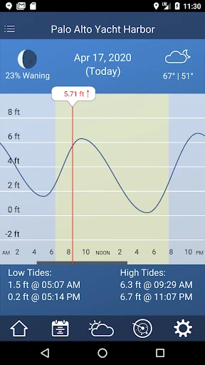
The core function of the Tide Charts app is to deliver accurate, location-based tide predictions. Users can view detailed tide charts showing high and low tide times and heights for thousands of stations worldwide. The app presents this data through clear, interactive graphs and daily listings. Beyond basic tides, it integrates solunar fishing calendars, indicating peak activity periods for fish and game based on sun and moon phases. Key features include a comprehensive seven-day forecast, sunrise and sunset times, moon phase tracking, and current weather conditions. The interface allows for easy switching between favorite locations, saving custom spots, and receiving alerts for specific tide conditions, ensuring all critical information is accessible at a glance.
Chapter 2: Value
The primary value of Tide Charts lies in its ability to demystify marine data, empowering users to make informed decisions that enhance both safety and success in their activities. Its key advantage is hyper-local accuracy, sourcing data from trusted authorities, which is crucial for navigation, beachcombing, or construction in intertidal zones. For anglers, the integrated solunar data provides a scientific edge, potentially increasing catch rates by identifying the best fishing windows. The app’s intuitive design presents complex astronomical data in a visually digestible format, saving users from manual interpretation of tables. Unlike generic weather apps, it offers specialized parameters like tidal coefficients and water temperature. The offline access to saved locations ensures functionality in remote coastal areas without cellular service. This focused toolset eliminates the need to consult multiple sources, consolidating vital marine intelligence into a single, reliable, and user-friendly platform, ultimately saving time and mitigating risks associated with misjudging tidal conditions.
Chapter 3: Scenarios
The Tide Charts app is indispensable for a wide range of user groups whose lives interact with the coast. Recreational anglers and commercial fishermen rely on it to plan trips around optimal feeding times indicated by the solunar calendar. Surfers use it to pinpoint the best tide and swell conditions for their local breaks. Beachgoers, kayakers, and boaters consult it for safe access, ensuring they are not caught by incoming tides. Marine researchers, coastal engineers, and environmental surveyors utilize the precise data for fieldwork planning. Shellfish harvesters depend on accurate low tide predictions to access beds safely. Photographers use it to plan shoots for dramatic coastal landscapes at low tide or golden hour. Essentially, anyone planning a day at the coast—from a family building sandcastles to a sailor navigating a narrow inlet—finds immense practical value in having a precise, forward-looking tide and marine weather forecast readily available in their pocket.
Key Pros
- Intuitive interface for easy navigation.
- Real-time tide data updates.
- Covers multiple global locations.
- Offline mode for remote access.
- Customizable alerts for tide events.
Things to Note
- Limited features in free version.
- Requires GPS for accurate data.
- Occasional data syncing issues.
- No integration with fishing apps.
- Ads in free version can be intrusive.
Frequently Asked Questions
Q: What is Tide Charts and what does it do?
A: Tide Charts is a specialized marine navigation app that provides detailed tide and current predictions. Its core function is to offer accurate tide tables, charts, and forecasts for thousands of locations worldwide. It is primarily used by boaters, anglers, surfers, and coastal enthusiasts to plan activities based on water levels and flow. The app typically displays high and low tide times, heights, and sun/moon data, positioning itself as an essential tool for safety and planning in marine environments.
Q: Is Tide Charts free to use, or does it have in-app purchases?
A: Tide Charts typically operates on a freemium model. The basic app is free to download and provides essential tide information for many locations. However, advanced features such as detailed offshore forecasts, extended historical data, ad-free experience, or access to premium chart layers often require a one-time purchase or a subscription. The specific pricing structure for in-app purchases or a 'Pro' version should be confirmed within the app's description on the official app store.
Q: What devices and regions does Tide Charts support?
A: Tide Charts is generally available for both iOS and Android mobile devices. It supports a wide range of smartphones and tablets. The app's primary adaptation scope covers coastal regions across the globe, with a particularly strong database for popular boating and fishing areas in North America, Europe, and Australia. It requires an internet connection to download the latest data, but many versions allow saving forecasts for offline use. Specific device compatibility should be verified on the respective app store listing.
Q: How accurate are the tide predictions in this app?
A: Tide Charts sources its predictions from official hydrographic offices and uses established astronomical models, making them highly reliable for general planning. However, accuracy can be affected by local weather conditions like strong winds and barometric pressure, which the models may not account for in real-time. Predictions for well-monitored stations are very precise, while those for secondary or interpolated locations may have slight variances. It is always recommended to use the app as a planning tool and observe local conditions for critical navigation.
Q: Can I use the app for navigation and is there customer support?
A: Tide Charts is designed as an informational aid for planning and must not be used as the sole means of navigation. Mariners should always consult official nautical charts and instruments. For after-sales maintenance, support is typically provided through an in-app contact option or a support email listed on the developer's website or app store page. Common issues like location errors or data discrepancies can often be resolved by checking GPS permissions, updating the app, or re-downloading data for the specific area.