PredictWind - Marine Forecasts
Weather
PredictWind Marine Weather Forecasts For Sailors
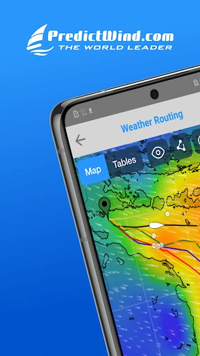
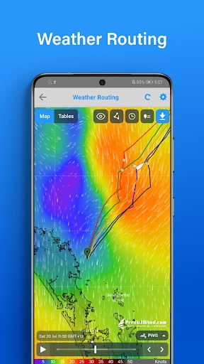
App Screenshots

About PredictWind Marine Forecasts Feature - The Professional Navigator's Digital Compass
PredictWind is a premier marine weather forecasting application designed specifically for sailors, boaters, and maritime professionals. It leverages a unique combination of proprietary and global forecast models to deliver highly accurate, granular wind, wave, and weather predictions for any location on the world's oceans and coastal waters. More than just a weather app, it integrates advanced routing tools, real-time vessel tracking, and customizable alert systems into a single, robust platform. Its core mission is to enhance safety, optimize voyage planning, and improve decision-making for anyone whose activities depend on precise and reliable marine meteorological data.
Chapter 1: Function
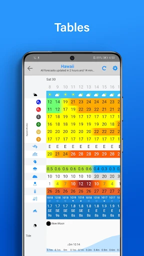
PredictWind's core functionality revolves around delivering superior marine weather intelligence. The app provides access to multiple high-resolution forecast models, including its own proprietary PWE and PWG models, alongside GFS and ECMWF data. Users can view detailed forecasts for wind speed and direction, wave height and period, precipitation, atmospheric pressure, and sea surface temperature through interactive global maps and location-specific graphs. A standout feature is its weather routing tool, which automatically calculates the fastest or safest passage between two points based on forecast conditions and vessel performance profile. Additionally, the app offers satellite imagery, real-time GPS tracking with shareable links, and customizable weather alerts for specific wind thresholds or storm warnings, ensuring sailors have comprehensive situational awareness directly on their mobile devices.
Chapter 2: Value
The primary value proposition of PredictWind lies in its unparalleled accuracy, specialization, and integration, which collectively foster safer and more efficient maritime operations. Its key advantage stems from running its own forecast models at higher resolution than public models, offering more precise and reliable predictions for complex coastal areas and open oceans. This accuracy is critical for safety, helping users avoid severe weather. The integrated weather routing transforms raw data into actionable intelligence, saving significant time and fuel by identifying optimal courses. For commercial operators and serious cruisers, this translates directly into cost savings and reduced vessel wear. The platform's consistency across web and mobile apps ensures seamless planning ashore and execution at sea. Furthermore, its global satellite data connection, via Iridium, provides reliable forecasts in the most remote ocean regions where cellular data is unavailable. This combination of precision, specialized tools, and offline reliability creates a trusted decision-support system. It mitigates risk, enhances confidence, and empowers users to make informed navigational choices, elevating it from a simple information source to an essential piece of onboard safety equipment.
Chapter 3: Scenarios
PredictWind primarily serves dedicated maritime users whose safety and success hinge on weather conditions. The foremost user group is offshore sailors and ocean racers, from participants in regattas like the Sydney to Hobart to global circumnavigators, who rely on its routing and long-range forecasts for voyage strategy and storm avoidance. Recreational boaters, including coastal cruisers, fishermen, and day-sailors, use it to plan weekend trips, ensuring comfortable conditions and safe returns. The app is equally vital for professional mariners, including commercial fishing fleet captains, superyacht crews, and delivery skippers, who use it for operational planning, fuel optimization, and meeting tight schedules safely. Everyday use cases involve checking detailed wind forecasts for an upcoming sailing area, setting a GPS track and monitoring progress against the predicted weather, receiving push notifications if wind speeds exceed a preset limit at an anchorage, and using the offline maps during a passage beyond cellular range. Ultimately, it is the go-to tool for any sailor moving from a casual observer of the weather to an active, data-driven manager of their maritime environment.
Key Pros
- delivers highly accurate wind and wave models for sailing routes
- offers proprietary grib file compression for low-bandwidth areas
- integrates real-time weather routing with vessel performance polars
- provides global forecast coverage with frequent model updates
- features offline map and forecast access for ocean passages
Things to Note
- requires subscription for advanced routing and premium models
- interface has a steep learning curve for casual boaters
- high-detail maps consume significant device storage locally
- real-time data sync depends on satellite coms offshore
- specialized features are overkill for inland or coastal day sailing
Frequently Asked Questions
Q: What is PredictWind and what does it do?
A: PredictWind is a specialized marine weather forecasting application for sailors, boaters, and maritime professionals. Its core function is to provide highly detailed wind, wave, and weather forecasts for offshore and coastal navigation. The app utilizes proprietary global weather models and advanced routing algorithms to help users plan safe and efficient voyages. It positions itself as a professional-grade tool for serious maritime navigation and planning.
Q: Is PredictWind free to use or does it require a subscription?
A: PredictWind operates on a freemium model. The app itself is free to download and offers basic forecast features and some global model data. However, full access to its most advanced features—including high-resolution forecasts, all global weather models (PWG & PWE), weather routing, satellite imagery layers, and GRIB file downloads—requires a paid subscription. Subscription plans are available monthly or annually.
Q: What devices and platforms is the PredictWind app available on?
A: The PredictWind app is widely available across major platforms to ensure accessibility on board. It offers native applications for iOS (iPhone/iPad) and Android devices. Additionally, its core forecasting and routing services are fully accessible via any modern web browser on desktop or laptop computers. This multi-platform approach allows users to plan on a computer and monitor conditions on a mobile device while on the water.
Q: How accurate are PredictWind's forecasts compared to other sources?
A: PredictWind is recognized for providing high-resolution, specialized marine forecasts. Its accuracy stems from running two proprietary global weather models (PWG & PWE) alongside integrating other major models like GFS and ECMWF. The app is particularly valued for its wind and wave forecasts, which are tailored for sailing performance and safety. Accuracy can vary by region and weather system, so cross-referencing with official sources is often recommended for critical decisions.
Q: Does the app work offline for use in areas with no cellular signal?
A: Yes, PredictWind offers robust offline functionality, which is critical for offshore use. Users can download high-resolution GRIB forecast files and satellite weather maps for their specific route area while connected to the internet. Once downloaded, these charts, forecasts, and routing data are fully accessible without any network connection. This feature is a core technical characteristic designed specifically for the reality of limited connectivity at sea.