Clime: NOAA Weather Radar Live
Weather
Live Weather Radar Alerts For Outdoor Plans
App Screenshots


About Clime: NOAA Weather Radar Live Features
Clime: NOAA Weather Radar Live is a professional-grade weather application that delivers real-time, hyper-local weather data and forecasts. It leverages authoritative sources like the National Oceanic and Atmospheric Administration (NOAA) to provide users with accurate radar imagery, severe weather alerts, and detailed meteorological insights. The app stands out for its high-resolution animated radar maps, which offer a dynamic view of precipitation, storms, and other weather patterns. Designed for both everyday planning and serious weather tracking, Clime transforms complex weather data into an accessible and interactive visual experience, empowering users to make informed decisions based on the latest atmospheric conditions.
Chapter 1: Function
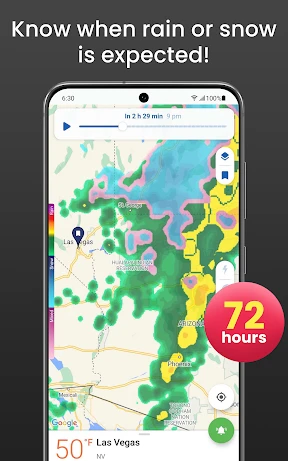
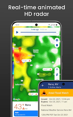
Clime's core functionality centers on providing live, animated weather radar and reliable forecasts. The app pulls data directly from NOAA's network of next-generation radar (NEXRAD), displaying high-resolution maps of precipitation, storm cells, and their movement in real time. Users can zoom in on any location for street-level detail, track past radar loops to see storm development, and observe future radar projections. Beyond the radar, the app offers detailed local forecasts including temperature, humidity, wind speed and direction, and sunrise/sunset times. A critical function is its severe weather alert system, which pushes notifications for warnings issued by NOAA, such as tornadoes, hurricanes, floods, and thunderstorms, directly to the user's device based on their precise location or monitored areas.
Chapter 2: Value
The primary value of Clime lies in its authoritative data source and superior visualization, offering peace of mind and proactive safety. By utilizing official NOAA radar and alert data, it provides a level of accuracy and timeliness that is crucial during severe weather events, distinguishing it from apps using less reliable sources. The high-definition, animated radar interface is its key advantage, allowing users to intuitively understand complex weather patterns, track storm paths, and gauge the intensity of approaching systems. This visual clarity is invaluable for planning. Furthermore, the app's customizable alerts ensure users are among the first to know about dangerous conditions affecting their specific area, which can be lifesaving. The value extends to various user groups: for the general public, it simplifies weather awareness; for outdoor enthusiasts, it aids in planning activities safely; and for weather hobbyists or professionals, it serves as a powerful, portable tool for observation. The ad-free experience in its premium version enhances usability, offering uninterrupted access to critical information. Ultimately, Clime translates vast meteorological data into actionable intelligence, empowering users to navigate their day with confidence and preparedness.
Chapter 3: Scenarios
Clime is ideally suited for individuals whose daily decisions or safety depend on precise, up-to-the-minute weather information. Primary user groups include outdoor professionals and enthusiasts such as farmers, pilots, boaters, hikers, and construction managers, who need to assess weather risks for their operations or leisure activities. It is equally valuable for residents in regions prone to volatile weather, like Tornado Alley or hurricane coastlines, providing them with an essential tool for monitoring threats and receiving early warnings. Everyday use cases are diverse: a family planning a picnic can check the radar for rain clouds; a commuter can view the storm's movement to decide the best time to travel; a parent can monitor lightning activity near their child's soccer game. During severe weather outbreaks, users actively track storm cells, their rotation indicated on radar, and rely on push notifications to seek shelter immediately. Travelers also benefit by monitoring weather at their destination or along their route, making Clime a versatile companion for both routine planning and emergency preparedness.
Key Pros
- displays animated future radar loops for forecasting
- integrates NOAA's authoritative meteorological data sources
- offers a minimalist
- ad-free interface for focused use
- provides timely severe weather push notifications
- uses high-resolution radar imagery for local precision
Things to Note
- lacks detailed textual forecasts or lifestyle features
- requires stable data connection for real-time map loading
- premium features need a subscription for full access
- interface may be too sparse for users seeking all-in-one apps
- regional coverage depth varies outside primary NOAA zones
Frequently Asked Questions
Q: What is Clime: NOAA Weather Radar Live?
A: Clime: NOAA Weather Radar Live is a weather app focused on providing real-time, high-resolution radar maps, severe weather alerts, and forecasts. It sources data directly from NOAA (National Oceanic and Atmospheric Administration) and other professional services. Its core positioning is as a reliable, radar-first tool for monitoring live precipitation, storms, and weather patterns with precision, catering to users who need detailed meteorological visualization.
Q: Is Clime a free app or does it require a subscription?
A: The app operates on a freemium model. You can download and use basic radar and weather features for free, which may include ads. Access to advanced features like future radar forecasts, hurricane tracking, high-resolution layers, and ad-free experience requires a Clime Premium subscription, available as a monthly or annual in-app purchase. Specific pricing details are available within the app or on the official app store listing.
Q: What devices and regions does this weather app support?
A: Clime is available for iOS and Android devices, including phones and tablets. Its primary data coverage is focused on the United States, utilizing NOAA's network for the most accurate and detailed radar information. It also provides basic weather data and satellite imagery for many other global locations, but the flagship real-time radar functionality is optimized for the U.S. territory.
Q: How accurate and timely are the severe weather alerts?
A: The app provides official NOAA severe weather alerts (like tornado, thunderstorm, and flood warnings) for the U.S. These alerts are pushed directly from governmental sources, ensuring they are timely and authoritative. The radar data is also updated frequently, typically every 5-10 minutes for live conditions. For critical life-saving decisions, always follow instructions from local authorities and emergency services.
Q: Can I use the radar maps without an internet connection?
A: No, an active internet connection (cellular data or Wi-Fi) is required to download the latest radar imagery, forecast data, and weather alerts. The app functions by streaming real-time and high-resolution map data from servers; therefore, core features are not available offline. Some basic saved location data might be cached, but for full functionality, a continuous connection is necessary.