Weather Forecast - Live Radar
Weather
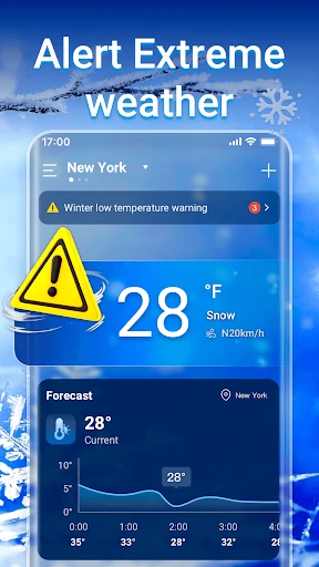
Accurate Hyperlocal Forecasts And Severe Weather Alerts
App Screenshots
About Weather Forecast - Live Radar Feature
Weather Forecast - Live Radar is a comprehensive mobile application designed to deliver precise, real-time weather information and dynamic radar maps. It serves as a reliable personal weather assistant, catering to users who need accurate forecasts and visual storm tracking. By integrating data from authoritative meteorological sources, the app provides detailed local and global weather conditions, including temperature, precipitation, wind speed, humidity, and severe weather alerts. Its standout feature is the interactive live radar, which offers animated precipitation maps, allowing users to visually track storm movements and weather patterns in near real-time. The app emphasizes user-friendly design, ensuring that critical weather data is accessible and understandable for both casual daily planning and serious weather monitoring.
Chapter 1: Function
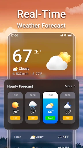
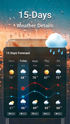
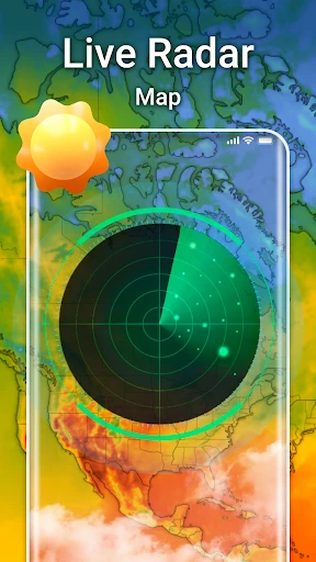
The core functionality of Weather Forecast - Live Radar revolves around two main pillars: detailed forecasting and interactive radar visualization. Firstly, the app provides hyper-local weather forecasts for any specified location, offering hourly and extended 10-day predictions. These forecasts include essential parameters such as temperature highs and lows, precipitation probability, UV index, sunrise and sunset times, and wind conditions. Secondly, and most distinctively, the app features a high-definition live radar map. This interactive map displays real-time precipitation types—rain, snow, sleet—using color-coded animations. Users can zoom, pan, and loop the radar imagery to observe the direction and intensity of weather systems. Additional functions include customizable severe weather push notifications for lightning, hail, or storms, the ability to save multiple favorite locations, and widgets for home screen convenience. Together, these tools transform complex meteorological data into actionable insights for daily decision-making.
Chapter 2: Value
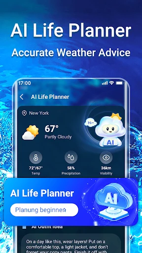
The primary value proposition of Weather Forecast - Live Radar lies in its fusion of accuracy, immediacy, and visual clarity, empowering users to make informed decisions based on reliable weather intelligence. Unlike basic weather apps, its advanced live radar feature provides unparalleled situational awareness, allowing users to see storms developing and moving rather than just reading about them. This proactive insight is crucial for safety, enabling timely precautions against severe weather. The app aggregates data from multiple professional sources, including national weather services and next-generation radar networks, ensuring forecast reliability. Its user interface is intuitively designed, presenting complex data through clear visuals and animations without overwhelming the user. For outdoor enthusiasts, professionals like farmers or construction managers, and everyday commuters, this translates into tangible advantages: optimized planning, reduced weather-related disruptions, and enhanced personal safety. The app’s ad-free experience in its premium version further adds value by offering uninterrupted access to critical information. Ultimately, it demystifies the weather, turning uncertainty into a manageable variable for both routine activities and emergency preparedness.
Chapter 3: Scenarios
Weather Forecast - Live Radar is ideally suited for a diverse range of users whose daily plans or safety are directly influenced by weather conditions. Primary user groups include outdoor workers and event planners, such as construction supervisors, landscapers, and wedding coordinators, who rely on precise, hour-by-hour forecasts and radar trends to schedule work and mitigate risks. It is equally valuable for travel enthusiasts and commuters, helping them navigate road conditions, plan routes around storms, or decide on flight delays. Parents and school administrators use it to anticipate school closures or plan children's outdoor activities safely. Furthermore, the app is indispensable for weather hobbyists and residents in regions prone to volatile weather, such as tornado alleys or hurricane coasts, who need real-time tracking of severe systems. Common use cases involve a user checking the radar loop in the morning to decide whether to carry an umbrella or postpone a picnic, receiving a push notification for an approaching thunderstorm while on a hiking trail, or a truck driver monitoring precipitation patterns across a long-haul route to ensure safe travel. In every scenario, the app acts as a critical tool for proactive life management.
Key Pros
- hyper-local minute-by-minute precipitation forecasts
- interactive 3D radar with storm tracking layers
- offline access to saved location weather data
- customizable severe weather alert thresholds
- displays real-time user-submitted weather photos
Things to Note
- radar animation consumes high mobile data
- complex interface for casual weather checking
- requires location permissions for full functionality
- specialized features overwhelm basic forecast needs
- 3D rendering performs poorly on older devices
Frequently Asked Questions
Q: What is Weather Forecast - Live Radar?
A: Weather Forecast - Live Radar is a mobile application focused on providing hyper-local weather forecasts and real-time animated radar maps. Its core positioning is to deliver precise, minute-by-minute precipitation tracking and severe weather alerts. The app utilizes data from official meteorological services and proprietary models to show rain, snow, and storm movements on an interactive map, helping users plan their activities.
Q: Is this app free to use, or does it have in-app purchases?
A: The app sources its data from established providers like government weather services and private networks. While forecasts and radar are highly reliable for short-term planning (0-6 hours), all weather predictions have inherent uncertainty. Accuracy can decrease for long-range forecasts or in regions with sparse radar coverage. The 'live' radar may have a slight delay (5-10 minutes) due to data processing and transmission.
Q: Can I use this app for severe weather alerts and notifications?
A: The app typically operates on a freemium model. The basic version offers standard forecasts and a delayed radar loop for free. For advanced features like real-time lightning strikes, future radar projections, hurricane tracking, or ad-free experience, a subscription or one-time in-app purchase is usually required. Specific pricing tiers are detailed within the app's store listing.
Q: What devices and operating systems does this app support?
A: Weather Forecast - Live Radar is primarily designed for smartphones. It is commonly available for both iOS (via the Apple App Store) and Android (via Google Play) platforms. Support for tablets, wearables (like Apple Watch), or widgets varies. The app generally requires a stable internet connection (cellular data or Wi-Fi) and location permissions for accurate local forecasts.
Q: How accurate is the live radar and forecast data?
A: Yes, a core feature is providing customizable severe weather alerts (e.g., for thunderstorms, tornadoes, floods) via push notifications. Users can usually set alert zones and severity levels. However, these are not a substitute for official emergency alerts from government authorities. For critical, life-threatening situations, always rely on official warnings from your local National Weather Service or equivalent agency.