Windfinder: Wind & Weather map
Weather
Windfinder Accurate Wind Forecasts For Sailors Surfers
App Screenshots


About Windfinder: Wind & Weather Map Feature
Windfinder is a specialized weather application focused on providing detailed wind and marine weather forecasts. It caters primarily to outdoor enthusiasts and professionals whose activities are heavily influenced by wind conditions and weather patterns. The app delivers precise, map-based visualizations of wind speed, direction, gusts, and other meteorological data. By aggregating information from various sources, including weather models and local stations, Windfinder offers reliable forecasts for thousands of locations worldwide. Its core appeal lies in transforming complex atmospheric data into an intuitive, interactive map interface, enabling users to make informed decisions for their wind-dependent plans.
Chapter 1: Function
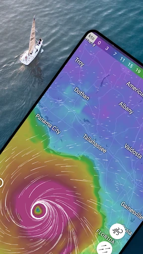
Windfinder's core functionality revolves around delivering hyper-specific wind and weather forecasts through an interactive map. The app displays real-time and forecasted data for wind vectors, including speed and direction, using animated overlays on detailed maps. Users can view forecasts for up to 10 days, with parameters such as wave height, wave period, air temperature, precipitation, and atmospheric pressure. Key features include wind alerts, favorite spot management, and detailed weather charts for specific locations. The app also provides specialized forecasts for kitesurfing, windsurfing, sailing, and fishing. Its offline map functionality allows access to saved forecast data without an internet connection, which is crucial for remote areas. Essentially, it functions as a dedicated meteorological tool that decodes wind patterns for practical application.
Chapter 2: Value
The primary value proposition of Windfinder lies in its precision and specialization. Unlike generic weather apps, it delves deep into the nuances of wind and marine conditions, offering a level of detail essential for safety and performance in wind sports and maritime activities. Its key advantage is the high-resolution, animated weather map that presents complex data intuitively, allowing users to visualize weather systems and trends at a glance. The app synthesizes data from multiple forecast models, providing a more reliable and comprehensive outlook. For professionals like sailors, pilots, or fishermen, this accuracy translates directly into risk mitigation and operational efficiency. For enthusiasts, it enhances the experience by identifying optimal conditions. The interface, while data-rich, is designed for usability, making professional-grade meteorological information accessible to a broad audience. Furthermore, its global coverage of countless spots, from major coasts to local lakes, ensures relevance for users worldwide. The offline capability adds significant practical value for adventurers beyond reliable network coverage. Ultimately, Windfinder delivers trusted, actionable intelligence, empowering users to plan with confidence and harness the power of the wind safely and effectively.
Chapter 3: Scenarios
Windfinder's primary target users are individuals engaged in wind-dependent outdoor sports and professions. This includes kitesurfers, windsurfers, sailors, paragliders, pilots, fishermen, and coastal hikers. For a kitesurfer, the app is used daily to check the forecast for their local spot, looking for the ideal wind strength and direction, and setting alerts for when conditions become favorable. A sailor planning a multi-day voyage uses Windfinder to study wind patterns and wave forecasts along the intended route, ensuring a safe and efficient journey. Fishermen utilize it to understand onshore and offshore wind conditions, which affect fish behavior and boat safety. Outdoor event planners, such as those organizing regattas or beach festivals, rely on its detailed forecasts for scheduling. Even casual users planning a beach day or a picnic might use it to check for strong winds that could disrupt their plans. In everyday use, a user typically opens the app to view the animated wind map for their region, saves favorite locations for quick access, consults the hourly and daily breakdowns, and uses the specialized weather parameters relevant to their activity, making Windfinder an indispensable tool for informed outdoor decision-making.
Key Pros
- hyper-local wind forecasts for sailing and kitesurfing spots
- interactive map layers show wind
- waves
- and pressure systems
- offline access to saved locations and weather charts
- wind alert notifications for specific speed and direction thresholds
- provides detailed meteogram forecasts for 10 days ahead
Things to Note
- pro features require a separate subscription purchase
- interface feels technical and cluttered for casual users
- high data density can slow loading on older mobile devices
- wave data coverage is limited outside major coastal regions
- free version includes frequent banner advertisements
Frequently Asked Questions
Q: What is Windfinder and what does it do?
A: Windfinder is a weather app focused on wind, waves, and weather conditions for outdoor sports and activities like sailing, kitesurfing, and fishing. Its core function is to provide hyper-local wind forecasts, real-time data from weather stations, and detailed weather maps. The app displays wind speed/direction, wave height/period, weather forecasts, and radar/satellite imagery, positioning itself as a specialized tool for wind-dependent planning.
Q: Is Windfinder free to use, or does it have in-app purchases?
A: Windfinder operates on a freemium model. The basic app is free and includes essential forecasts and current conditions. A paid PRO subscription removes ads, provides access to advanced forecast models (like ECMWF), offers long-range forecasts, and enables additional features such as weather map overlays and personalized favorite spots. In-app purchases are required for the PRO tier, with no additional physical equipment needed.
Q: What devices and operating systems does Windfinder support?
A: Windfinder is available as a native app for iOS (iPhone/iPad) and Android devices, and also has a fully functional website. The app adapts to different screen sizes and supports recent versions of the operating systems. It is designed for a broad user group, primarily outdoor enthusiasts, mariners, and pilots, but does not require specialized hardware beyond a standard smartphone or tablet with internet connectivity.
Q: How accurate and detailed are Windfinder's wind forecasts?
A: Windfinder aggregates data from various sources, including official weather services and its own network of weather stations, for real-time conditions. Forecasts are based on models like GFS and, for PRO users, ECMWF. Accuracy is high for short-term forecasts (1-3 days) but diminishes for longer ranges, which is typical for meteorological models. The detail is exceptional for wind and waves, offering parameters like gusts, direction arrows, and hourly breakdowns.
Q: Can I use Windfinder offline or report data issues?
A: Limited offline use is available; you can view saved locations and forecasts if accessed previously while online, but real-time data and maps require an internet connection. For data discrepancies or station malfunctions, you can report issues directly through the app or website. The support team handles these reports, but updates depend on the data source. There is no direct phone support; communication is via email or contact forms.