Weather Forecast (Radar Map)
Weather
Accurate Local Weather Forecasts With Live Radar Maps
App Screenshots


About Weather Forecast (Radar Map) Feature – Precision at Your Fingertips
Weather Forecast (Radar Map) is a modern meteorological application that delivers highly accurate, real-time weather information and future forecasts through an intuitive radar map interface. It integrates data from authoritative global weather services, providing users with detailed insights into precipitation, storm movements, temperature fluctuations, and other critical atmospheric conditions. The app is designed for individuals who require reliable and timely weather updates to plan their daily activities, travel, and outdoor events effectively. With its focus on visual data representation and user-friendly design, it transforms complex meteorological data into accessible and actionable intelligence.
Chapter 1: Function
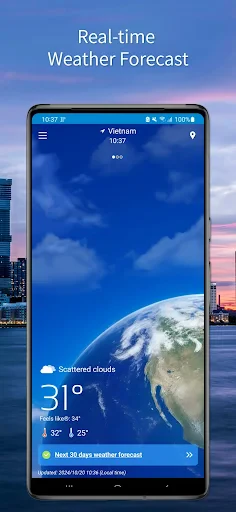
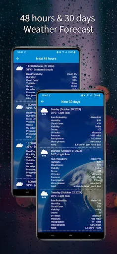
The core functionality of Weather Forecast (Radar Map) revolves around its dynamic, interactive radar map. This feature displays real-time precipitation, cloud cover, and storm systems moving across a geographical area, allowing users to zoom, pan, and animate the radar loop to track weather patterns. Beyond the map, the app provides standard weather forecasts including hourly and 7-14 day outlooks for temperature, humidity, wind speed and direction, UV index, and sunrise/sunset times. It supports severe weather alerts for specified locations, notifying users of storms, hurricanes, or extreme temperatures. Additional functions often include customizable widgets for the home screen, the ability to save multiple locations, and detailed meteorological charts. The app typically sources data from professional services like NOAA or national meteorological agencies, ensuring the information is both current and reliable.
Chapter 2: Value
The primary value proposition of Weather Forecast (Radar Map) lies in its empowerment of users through predictive clarity and situational awareness. Unlike basic forecast apps that offer simple icons and temperature readings, this app provides a visual, data-rich narrative of the atmosphere. The key advantage is the animated radar map, which demystifies weather patterns. Users can see exactly where rain is starting or stopping, how fast a front is moving, and the intensity of precipitation—information crucial for making immediate decisions, such as postponing a commute, rescheduling an outdoor event, or preparing for severe weather. This visual tool transforms users from passive recipients of forecasts into active analysts of their local environment. Furthermore, the app's reliance on authoritative data sources ensures high accuracy, a critical factor for professionals in agriculture, logistics, event planning, and outdoor recreation who depend on precise weather intelligence. The interface is typically designed for efficiency, presenting complex data in a layered, comprehensible manner without overwhelming the user. By consolidating real-time radar, detailed forecasts, and proactive alerts into a single platform, the app delivers exceptional convenience and reliability. It saves time, reduces uncertainty, and enhances personal safety by providing the tools to anticipate and react to weather changes proactively, making it an indispensable utility in daily life.
Chapter 3: Scenarios
The app serves a diverse range of user groups whose daily routines are significantly influenced by weather conditions. Primary users include outdoor enthusiasts such as hikers, cyclists, golfers, and campers who need to plan activities around precipitation and storms to ensure safety and enjoyment. Commuters and travelers rely on the radar map to time their journeys, avoiding getting caught in heavy rain or snow while driving or using public transport. Parents use it to decide on appropriate clothing for their children or to plan playground visits. Professionals in agriculture, construction, and event planning depend on its accurate, hyper-local forecasts and radar imagery to schedule critical work, protect assets, and manage operations efficiently. In regions prone to volatile weather, such as areas with frequent thunderstorms, hurricanes, or blizzards, the app becomes a vital tool for general preparedness, allowing residents to monitor developing threats in real-time. Everyday use cases are simple: checking the animated radar in the morning to decide whether to carry an umbrella, monitoring a winter storm's progression throughout the day, receiving a push notification for a sudden thunderstorm warning while at a park, or planning a weekend barbecue by examining the hourly forecast and cloud cover predictions. It is the go-to source for anyone seeking more control and insight over how the weather will impact their immediate plans.
Key Pros
- real-time animated radar map shows precise precipitation movement
- hyper-local minute-by-minute forecasts for specific addresses
- offline access to saved location weather data
- seamless layer toggling between radar
- satellite
- and temperature
- customizable severe weather alerts based on personal thresholds
Things to Note
- high battery consumption during continuous radar animation
- requires precise location permission for micro-forecasts
- radar data latency in remote mountainous regions
- complex interface with steep learning curve for seniors
- premium features locked behind subscription model
Frequently Asked Questions
Q: What is the core function of Weather Forecast (Radar Map)?
A: Weather Forecast (Radar Map) is a weather application focused on providing hyperlocal forecasts and real-time animated radar maps. Its core function is to deliver precise, location-based weather predictions including temperature, precipitation chance, wind speed, and severe weather alerts. The app positions itself as a tool for detailed planning by visualizing storm movement and precipitation intensity through interactive radar maps.
Q: Is this weather app free to use, or are there in-app purchases?
A: The app is free to download and use for basic weather forecasts and radar viewing. It may offer optional in-app purchases, such as a premium subscription, to remove ads, provide more detailed forecast models, offer longer-range radar loops, or deliver enhanced severe weather notification features. The specific pricing and features for any premium tier are detailed within the app's store listing or settings menu.
Q: On which devices and operating systems is the app available?
A: Weather Forecast (Radar Map) is primarily available for smartphones and tablets. It is typically developed for both iOS (via the Apple App Store) and Android (via Google Play) operating systems. For specific version requirements (e.g., iOS 14.0 or Android 8.0 and above), users should check the official app store listing, as compatibility may vary and updates can change minimum system requirements.
Q: How accurate and detailed is the animated radar map feature?
A: The animated radar map displays real-time and forecasted precipitation using data from official meteorological services or proprietary models. It shows movement, intensity (often color-coded), and types of precipitation. Accuracy depends on the data source and local coverage; it is generally reliable for short-term forecasting (0-6 hours) but is an interpolation and should be used as a guide alongside official warnings. The refresh rate and loop length are technical characteristics defined by the app.
Q: Does the app require specific permissions or drain battery quickly?
A: The app requires location permissions (precise or approximate) to provide localized forecasts and radar data. It may also need network access to update data. Battery usage is typically moderate; continuous use of GPS for precise tracking or frequent background updates can increase drain. Users can often manage battery impact by adjusting update frequency and location accuracy settings within the app or their device's system settings.